

Into the Dolomites: My Recon for Run the Alps’ 2019 Trip
Run the Alps is now offering a trail running trip in the Italian Dolomites. (You can see the trip here.) With smooth, flowy single-track, well-equipped high huts, and great meals along the way, it’s one of our favorite new areas.
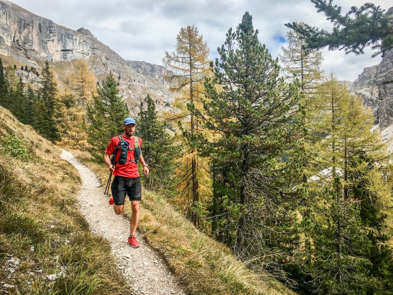
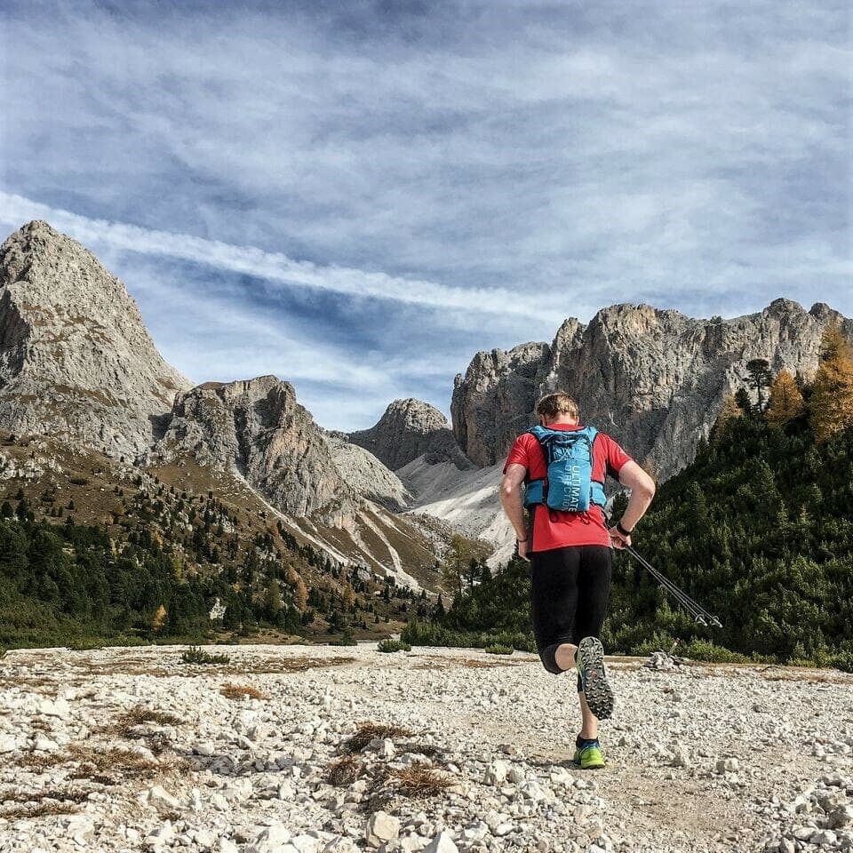
Run the Alps Senior Guide Bruno Yates will be leading our tour. Here’s the story of one of his trips to the Dolomites to preview the route. He ran with Run the Alps guide and photographer, Mark Brightwell.
Day 1: Into Ortisei
Ortisei seemed surprisingly lively as I arrived mid-afternoon in my aging camper van. Through a little on-line research and chats with those in the know, I had gathered that mid-October was distinctly out of season. Short of tumbleweed blowing down the main street, I hadn’t expected to find much going on. Traditionally, this is the time of year when locals, hoteliers and restauranteurs take their holidays between the busy summer and winter tourist seasons.
Instead, I found a party in full swing with hundreds of people cruising the main street, merchants at stalls selling roasted chestnuts and freshly baked strudel, a couple of bands playing, and several outdoor bars providing the means to lubricate the whole affair!
I met up with my friend, Mark, fellow Run the Alps guide and running partner for the week. We scratched our heads a bit and then decided the best way to get to the bottom of things was to buy some strudel and beer and question the locals. This suited me fine. The original plan had been to hit the trails that afternoon, but a seven-hour drive from Annecy, France through no fewer than five alpine nations had left me feeling weary and in need of refreshment. Mark had also just finished a late season tour over in Bavaria and was happy to rest his legs a bit. We had big plans for the following day anyway, so it made sense to spend the rest of the afternoon checking out the town rather than the mountains.
Ortisei sits nestled in Val Gardena in the heart of the UNESCO world heritage Dolomites mountain range. Although it has a resident population of 4,600, it boasts a staggering 870,000 overnight stays per year. The majority come for the winter ski season, but a large number also find their way here for the awesome hiking to be had in the surrounding mountains during the summer months. It is less well-known as a trail running destination than the likes of Chamonix, France but we were here this week to help rectify that situation! And it’s a situation that deserves to be rectified, as you’ll read shortly.
Although the Dolomites are in Italy, the people here in Ortisei would generally proudly identify themselves as Tyrolean, first. Val Gardena is situated in the South Tyrol region, which enjoys a large degree of autonomy from the Italian government. Fought over between Austria and Italy in the First World War, Tyrol has a complicated history which is reflected on local maps and signposts, which list everything in three languages – Italian, German and Ladin, a Romance language distinct to the region.
Mark and I, it turns out, had stumbled upon the “Segra Sacun” village festival and autumn market. It takes place each year on the second Monday of October. Besides being an opportunity to enjoy a variety of regional food and drink, it is also a chance for local men to buy a traditionally decorated pear for their beloved as a sign of their affection! We opted out of buying the pears, being many miles from our loved ones. Instead, we found the edge of a fountain to prop ourselves on and while soaking up the atmosphere. We proceeded to pore over a topographic map and hatch a plan for the next day!
Day 2: The Val Gardena
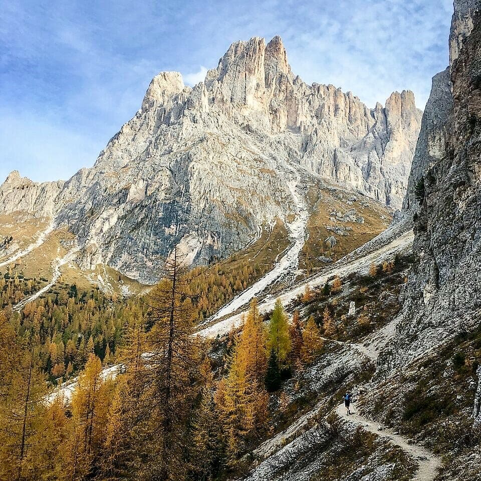
To scout the area in preparation for the tour in 2019, we opted for a big day out to the south of Val Gardena. The Dolomites are characterized by jagged limestone peaks which tower over high alpine pastures and deep valleys below. Arriving at the top of the Mont Seuc cable car to start our run, we were immediately struck by the beauty of the area. Early morning mist hung over the alpine meadows, stretching out for miles, dotted with chalets and crossed by trails. The massifs of Schlern and Langkofel provided an impressively steep and rugged backdrop to the idyllic landscape that unfolded before us.
We were soon in our stride and I was impressed with the quality of the trails and how runnable they were. Five miles flew by before the angle kicked up and we transitioned from the alpine plateau to the first massif of Schlern. The path became more rocky and technical and the views only improved as we gained altitude. It felt great to be out discovering new routes, and as we reached the top of our climb and looked at the ridge line ahead of us, we realized it was unlikely there would be any dull moments today! The sun was now high in the sky as the traversing trail wound its way between limestone towers, massive cliffs and plunging valleys.
We only lamented the fact the alpine refugios, or hütte in German, we passed from time to time were already closed for the season. Often improbably placed, perched on a cliff edge or tucked into a narrow mountain pass, these establishments offer welcome sustenance to weary hikers or runners. As I chomped on an energy bar pulled from my vest, I marvelled at the wonderful outlook from the Plattkofel hütte and consoled myself that next June I’d be sitting here with my group, drinking freshly brewed cappuccinos served with homemade tart!
The afternoon led us to a spectacularly placed hut, the Refugio Vicenza in the heart of the Sassolungo massif. It is situated in an old glacial cirque, surrounded by a horseshoe of steep cliffs, topped by bristling ridges and very pointy peaks. We entered by the mouth of the horseshoe from the west, but snuck out via a hidden and improbable rocky pass, the Forc Sassolungo, to the east.
The highlight of the day followed shortly as we wound our way along a trail on the upper edge of treeline. In what I can only describe as a rock garden, huge boulders interspersed with pine, juniper and larch made for the prettiest of scenery, colors vivid with the sun now low in the sky. We only wished for fresher legs to have gotten the most out of this absorbing trail. Arriving back down in the valley we had clocked 41 kilometers with 2200 meters of climbing. We were tired, but it was that satisfying fatigue that comes after a challenging day packed full of a little bit of everything!
Day 3: The Vallunga, or “Long Valley”
After the previous big day out, Mark and I opted for a shorter route with a run up and around the rim of the aptly named Vallunga, or “Long Valley”. We started and finished in Selva, a pretty village up from Ortisei and earmarked for an overnight stay on our upcoming Run the Alps tour. The sky was a little more gray and brooding than the day before, but no rain was forecast and the contrast would be interesting. The trough-shaped valley is about 6km long and features 500m high cliffs on both sides. There are only a few places where pathways breach these natural ramparts. We were able to exploit one of these to reach the scenic trail which circles the valley on the high ground above.
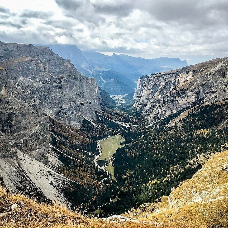
A steep climb brought us to the high point of the day, Forcela de Crespeina at 2528m. (It’s always nice to get the climbing done early on!) What remained was a flowing trail across open rocky terrain with dramatic views of Puezspitz on our left, one of the principal peaks of the area standing at nearly 10,000 feet. As we passed the now closed Puez hütte I had another vision – this time of espresso and apple strudel, sitting on the terrace in the warm early summer sun. Something to look forward to! The hut sits at the head of Vallunga and the view down the valley was as magnificent as anything we’d seen. One could really appreciate the power of nature when imagining a gigantic sea of ice carving out this deep glacial trough 15,000 years ago.
Perhaps the best part of the day was the run down! We found another of the breaches in the cliff wall and descended 700 meters into the lower valley in around 15 minutes. The trail started steeply and it was necessary to fight gravity to control our speed, as we weaved our way through the boulders and natural rock steps. Soon, however, the angle eased to a gradient where we could let ourselves go and allow gravity to assist. Intense concentration was still required to keep our footing and the conversation stopped as Mark and I became absorbed in the moment and fully focused on the trail. “Is this what you call ‘flow’?”, I wondered. It certainly felt great!
Day 4: Crossing the Wild Forc di Mesdi
An authentic Italian pizza from a small restaurant in Ortisei the previous evening went some way towards topping up our energy reserves, as we set out on our third run of the week. Our legs were a little stiff and the cold morning air made it hard to get going. However, the first part of our route was on south-facing slopes and as we emerged from the shaded lower valley into the morning sunshine, our spirits lifted and our legs found a rhythm. Our morning objective was a big loop taking in the pretty southern pastures of the Massif Odle Geisler. In the afternoon, we planned to tackle the massif’s rugged northern slopes. In order to achieve this, we would cross the wildest mountain pass of the week, the Forc di Mesdi, at nearly 2600m altitude.
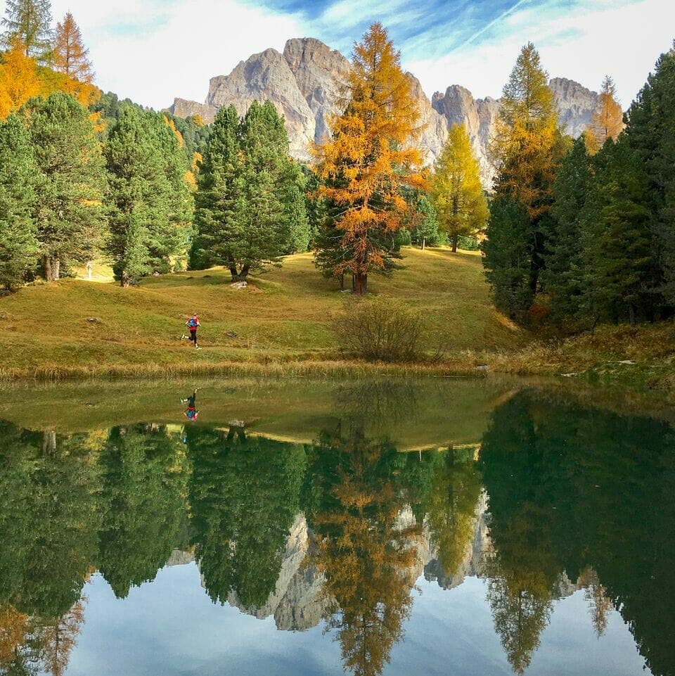
The trails and the weather that morning were so good that we ended up doubling our planned distance! Instead of following the logical line up to the pass, we detoured left and made a roughly circular tour of the Alm, a German name for high alpine pasture. In doing so, we discovered a gem of a mountain lake. Some patches of alpine flowers were still clinging onto the last remnants of summer, as we crossed a field of friendly donkeys.
Too soon, however, our little sojourn amongst the pretty fields and flowers and alpine chalets was over. It was time to tackle the big project of the day. The trail up to the pass seemed impossibly steep and surely the preserve of climbers and mountaineers. As we stood with craned necks at the base, we were able to pick out parts of the trail; steep switchbacks amongst the scree and boulders. In fact, we had already gained a decent chunk of altitude to get here, and it was only around another 300 meters to the top. We set out and the slope quickly reared up. I checked the altimeter on my watch often, and repeated my optimistic comment, customary in such situations, “At least when it’s steep you gain height quickly!” The angle relented near the top, and I summoned the energy to nod a greeting to a couple we passed going the other direction. I didn’t envy their descent, although I soon came to realize they were probably thinking the same for our ascent, as we continued up.
We lingered briefly at the pass, before a sharp breeze forced us into our descent. It was again steep and very engaging. The northern slopes of any mountain range in the northern hemisphere are generally steeper and more rugged since they receive less sunshine and were therefore more heavily glaciated in the past. This slope was no exception, and the pathway required our full attention to safely navigate some exposed and eroded sections. My knees started to creak a bit around what felt like the fiftieth switchback, but before long we were back onto mellower trails through pleasant pine forest and headed for the final waypoint, the Passo di Brogles. Fortunately, this one only required fifty meters or so of re-ascent, and we were now back in the sunshine. An open grassy area next to the now-shuttered Refugio di Brogles presented an irresistible opportunity to sit…. then lie down…. then nap for 15 minutes, before the fast descent to Ortisei.
Day 5: Into the Val Funes
Our last day in the Dolomites presented a whole new area to explore. The previous evening we had driven from Val Gardena, around to its quieter and more northerly neighbor, Val Funes. Mark and I hatched a plan to run a counter-clockwise tour of the Odle di Eores massif. Our challenge was to get it all done by 11am, as we both had long drives to complete that afternoon. So 8am saw us heading out, the morning chill biting at our fingertips and a coating of frost necessitating the odd gazelle-like leap over icy patches on the trail. The route featured the usual suspects: engrossing singletrack trail, mature pine woodland, abundant mountain vistas and a couple of well-placed huts for refreshments along the way…. well, come next June.
The highlight of the route was a traversing path on the northern slopes of the massif. Named on maps as “Gunther Messner way”, this trail flowed, but was narrow, occasionally exposed and completely absorbing. It was a fitting finale to our week in the Dolomites – probably the most technical trail that we had run and in a wild setting, with jagged peaks and steep scree slopes alongside us. Mark and I revelled in the setting, taking turns out front. “This is the kind of place I expect to see a wolf,” Mark commented, somewhat off-hand. I concurred, but was kind of glad that no wolf appeared around any of the corners. There has been a lot of media attention in recent times about “rewilding” in the Alps and the return of some of the big predators. We are both in agreement that this is a fantastic shift back toward a more balanced ecosystem. But, sightings of wolves, bears and lynx and still very rare here.
The morning was topped off with more great single-track on the south side of the massif. The trail weaved its way through the upper edge of the forest and the morning sun warmed the trees, causing them to give off a fragrant, distinct pine woodland scent. We achieved our 11am deadline with 12 miles and 1300 meters of height gain under our belts. Not wanting to arrive at our destinations smelling as if, well, we’d just run 12 miles and climbed 1300 meters, we took an icy cold plunge into a nearby mountain stream that was both cleansing and revitalizing!
The stats for the week stood at over 100k, or about 60 miles, run and over 5000m, or about 16,500 feet of climbing. We were pleased with ourselves, having ticked off a strong push through the Dolomites.
What these figures don’t tell you, however, is the sheer quantity of what I would describe as world-class trails. I’m used to running in some pretty incredible locations in the French and Swiss Alps, and I was blown away by what we found in this part of the Dolomites. I’m already looking forward to next June!
